Researchers develop real-time crop productivity estimation method
- Like
- Digg
- Del
- Tumblr
- VKontakte
- Buffer
- Love This
- Odnoklassniki
- Meneame
- Blogger
- Amazon
- Yahoo Mail
- Gmail
- AOL
- Newsvine
- HackerNews
- Evernote
- MySpace
- Mail.ru
- Viadeo
- Line
- Comments
- Yummly
- SMS
- Viber
- Telegram
- Subscribe
- Skype
- Facebook Messenger
- Kakao
- LiveJournal
- Yammer
- Edgar
- Fintel
- Mix
- Instapaper
- Copy Link
Posted: 6 March 2020 | Sam Mehmet (New Food) | No comments yet
The new real-time crop productivity estimation method uses satellite data, field measurements and camera networks, and aims to offer useful information to farmers and growers.
University of Illinois (uoI) scientists, with help from members of the Illinois Corn Growers Association, have developed a new method for estimating crop productivity in real time. The research combines field measurements, a unique in-field camera network, and high-resolution, high-frequency satellite data, which aim to provide highly accurate productivity estimates for crops across Illinois and beyond.
“Our ultimate goal is to provide useful information to farmers, especially at the field level or sub-field level. Previously, most available satellite data had coarse spatial and/or temporal resolution, but here we take advantage of new satellite products to estimate leaf area index (LAI), a proxy for crop productivity and grain yield. And we know the satellite estimates are accurate because our ground measurements agree,” said Hyungsuk Kimm, a doctoral student in the Department of Natural Resources and Environmental Sciences (NRES) at UoI and lead author on the study.
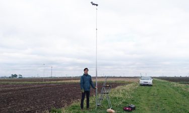
University of Illinois doctoral student Hyungsuk Kimm set up a network of cameras in corn fields around Illinois to ground-truth satellite-based algorithms to monitor corn productivity in real time.
Credit: Hyungsuk Kimm, University of Illinois.
Kimm and his colleagues used surface reflectance data, which measures light bouncing off the Earth, from two kinds of satellites to estimate LAI in agricultural fields. Both satellite datasets represented major improvements over older satellite technologies; they can “see” the Earth at a fine scale (three-metre or 30-metre resolution) and both return to the same spot above the planet on a daily basis. Since the satellites do not capture LAI directly, the research team developed two mathematical algorithms to convert surface reflectance into LAI.
While developing the algorithms to estimate LAI, Kimm worked with Illinois farmers to set up cameras in 36 corn fields across the state, providing continuous ground-level monitoring. The images from the cameras provided detailed ground information to refine the satellite-derived estimates of LAI.
In the end, the satellite LAI estimates from the two algorithms strongly agreed with Kimm’s “ground-truth” data from the fields. This result reportedly means the algorithms delivered highly accurate, reliable LAI information from space, and could be used to estimate LAI in fields anywhere in the world in real time.
“We are the first to develop scalable, high-temporal, high-resolution LAI data for farmers to use. These methods have been fully validated using an unprecedented camera network for farmland,” said Kaiyu Guan, Assistant Professor in the Department of NRES and Blue Waters Professor at the National Center for Supercomputing Applications.
The satellite method could reportedly detect underperforming fields or segments of fields that could be corrected with targeted management practices such as nutrient management, pesticide application, or other strategies. Guan plans to make real-time data available to farmers in the near future.
Related topics
Research & development, Sustainability, Technology & Innovation